REACH is a leading humanitarian initiative providing granular data, timely information and in-depth analysis from contexts of crisis, disaster and displacement.
Access humanitarian data through REACH
If you’re starting a new project and want to get an overview of the context head to the REACH Resource Center website. There you can find maps, reports and raw humanitarian data providing in-depth analysis of crises, disasters or displacement situations.
You can browse the data by filtering by country or by one of the 12 different themes. They have static maps and reports and in some cases excel files so you can investigate the humanitarian data yourself. The advanced search option lets you filter the data even further.

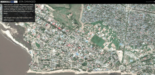
REACH also has a set of interactive dashboards and stories which they create with the help of ArcGIS. The data stories like the one on Cyclone Idai in Mozambique takes you through the crisis and talks about the amount of devastation and what was done to help.
REACH works with other agencies at a global level and in the field to strengthen efficiency in planning and service delivery, no matter the location. REACH works with the global cluster system such as the Global Protection Cluster, and the Global Education Cluster. REACH also works with several UN agencies and international organizations, including UNHCR, UNICEF, and OCHA. Other partners include the Red Cross, CartONG, and the International Displacement Monitoring Centre. For more information view the full list of REACH partners.
REACH’s humanitarian data resources:
- Data stories
- Interactive websites
- Reports - Excel files with humanitarian data from dozens of different contexts.